Versão portuguesa aqui.
GPS 38.769786295548805, -9.49380145725443
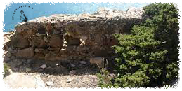
In addition to Forte da Roca, it was also called Fort of Nossa Senhora da Roca, or Fort of Espinhaço. Currently it is a ruin with nothing left other than a small part of the walls.

The first known reference to this fort is a plan, dated 1692, from the Casa do Cadaval Archive, but the fort must have been built much earlier. According to Carlos Pereira Callixto, 1980, the fort was built by the Count of Cantanhede, D. António Luís de Meneses, at the end of the reign of D. João IV or those of his two sons, D. Afonso VI or D. Pedro II. If true, the construction of this fort was part of a set of fortifications designed to protect the sea coast during the war of independence, after the 1640 revolution.
Being located in an area of difficult access, the fort fell into decay and in 1751, according to a kingdom inspector, it was quite dilapidated. However, there must have been restoration work because in 1777 the magazine was in good condition, with several artillery pieces. Even with some more work at the beginning of the 19th century, in 1813 there were no longer any weapons there or the existing ones were old. In 1829 it was no longer mentioned in its military role, which led to it being abandoned.

According to the description in the 18th century, it referred to a small fort, annexed dependencies for accommodation, warehouse and magazine. The garrison, according to documents in the Torre do Tombo, consisted of 5 soldiers, 2 artillerymen and a corporal, with 4 pieces of iron and 1 of bronze.
Access via Rua da Paredinha, in Azóia.

Full list of Geochaching below:
*Released*✅ *Reviewed*✅ Approved✅
Curator Body
0x38E76BCd1D7ff8675Ec4E30434c70123953Cf8C1 0x9A6F0Df3BE30246b199AC4b5106e2ac2FCD070f2 0x989Dfaf2c9Ff9e67B055A74BE928b2599906D3C9 0xD989E9E0cc7D16F58357197e305D79d43ca63F0F 0x49478e011f68357F4Af38B92EADa8D7ddfE7e7Dc